
Benard Okello
Geospatial Researcher/Specialist & Data Analyst
Bridging spatial science and data analytics to deliver research-driven insights for real-world decisions.
Welcome to my portfolio! I am a seasoned GIS specialist with ten years of experience in geospatial analysis, remote sensing, environmental management, and a strong focus on geospatial research, applied spatial statistics, and bridging spatial and non-spatial data for comprehensive insights.
Throughout my career, I have led and contributed to various large-scale projects, utilising cutting-edge GIS technologies and tools to provide critical data analysis and support decision-making. My expertise spans from agricultural monitoring, infrastructure development, and data management, equipping me to deliver high-quality geospatial solutions tailored to diverse sectors.
My projects extend beyond applied GIS, contributing valuable insights to geospatial research.

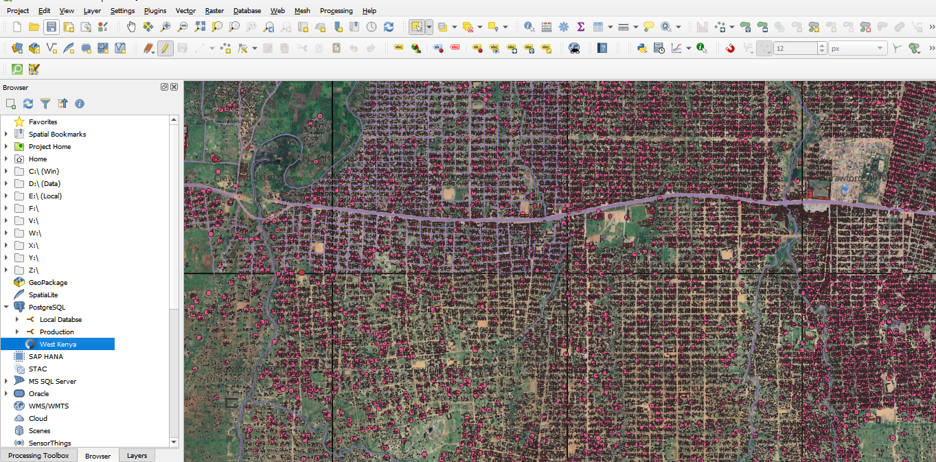
Led a team of 70 mappers to collect and analyse geospatial data to update the agricultural database for Kabras Sugar. We utilised smartphones with GPS for field data collection, allowing us to gather precise information about cane field boundaries and farmer details.

Played a crucial role in creating the fundamental GIS datasets needed for the construction of the Kenyan Standard Gauge Railway (SGR). This project involved mapping all features along the established corridor, developing detailed terrain models, and identifying key ecosystem areas affected by the railway's path.

Tasked with the comprehensive update of the GIS database for Uganda's Entebbe International Airport. Utilised expertise in ArcGIS and AutoCAD to manage spatial data compilation, integrate new geospatial information, and create detailed maps.

Managed several GIS projects focusing on environmental monitoring and conservation efforts. Analysed satellite imagery, conducted environmental data analysis, and developed geospatial solutions for monitoring changes in land use, vegetation, and ecosystems.
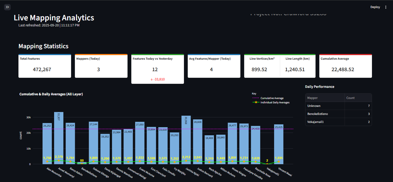
Developed a comprehensive Land Information Management System for Juba, South Sudan. This involved base mapping and integrating data from a PostgreSQL database with QGIS for detailed land use management layers. The project culminated in dashboard visualizations for effective project management and progress tracking.
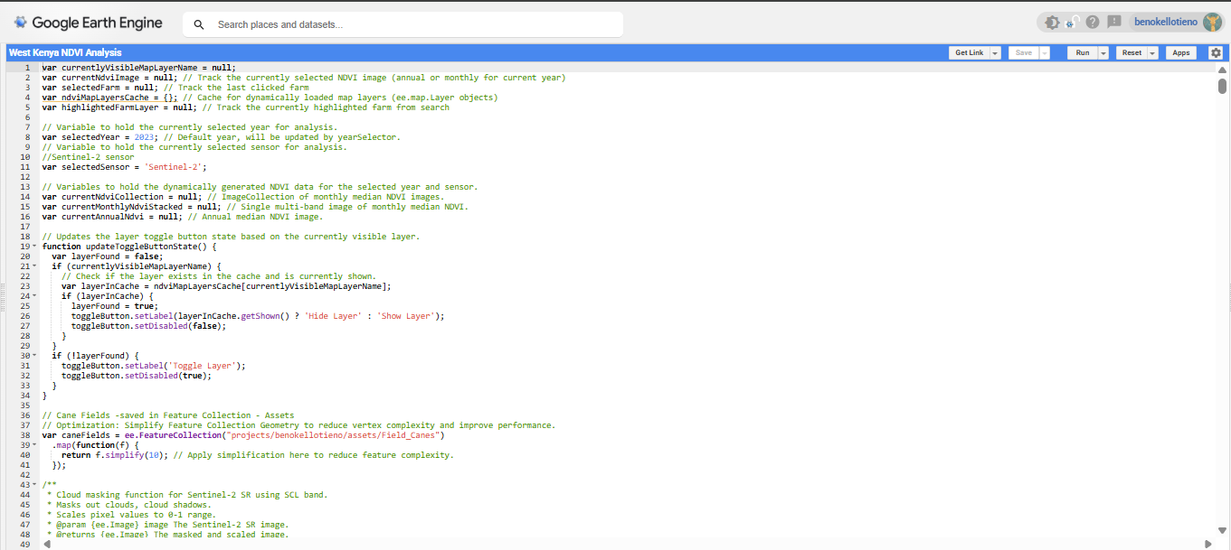
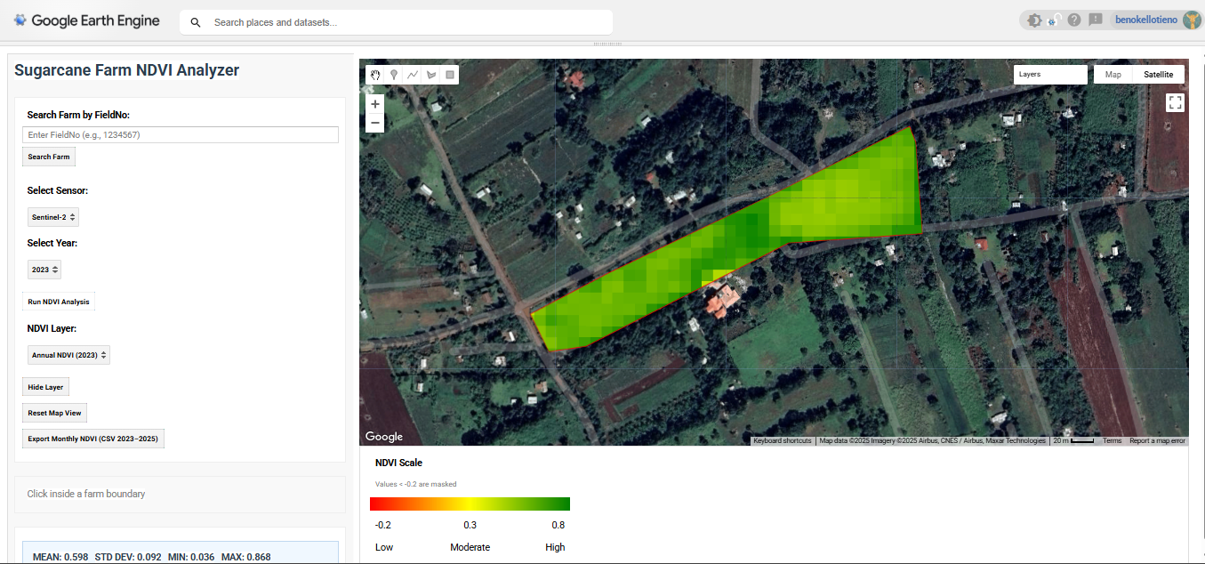
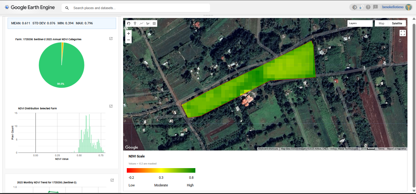
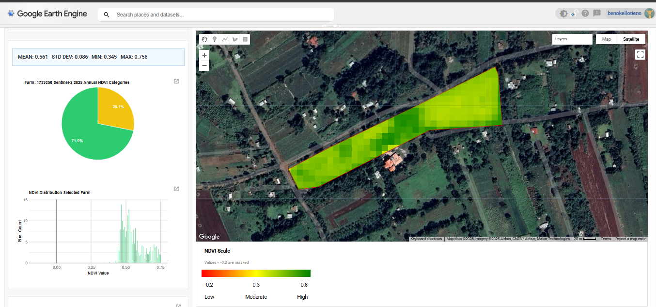
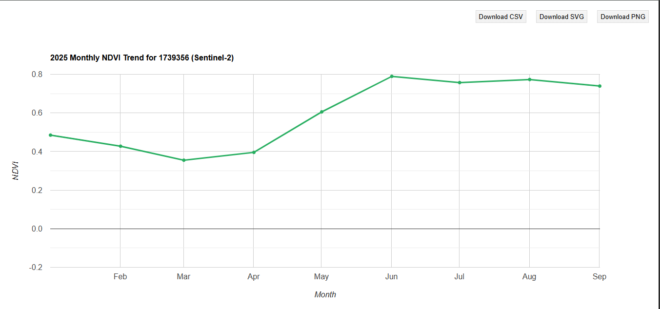
Developed an advanced crop management system for over 100,000 agricultural fields in West Kenya. This system leverages Normalized Difference Vegetation Index (NDVI) technology to monitor crop growth and health, providing critical insights for optimized agricultural practices and yield prediction. The project involved large-scale data processing and the implementation of a robust analytical framework.
Building strong professional relationships and collaborating effectively with diverse teams.
Interpretation, diagnosis and proactive problem-solving in complex situations.
Unrelenting pursuit of project goals with focused determination.
Clear articulation of technical concepts to diverse stakeholders.
Efficient prioritisation and execution of tasks to meet deadlines.
Effective assignment of responsibilities to optimise team performance.
Analytical approach ensuring precision in all deliverables.
Guiding teams to success with vision and inspiration.
Applying rigorous methodologies to explore complex geospatial problems and derive actionable insights.
Proven ability to train and mentor teams, enhancing their skills in geospatial data collection and analysis, as demonstrated by leading a team of 70 mappers.
University of California (Coursera)
University of Toronto (Coursera)
Esri